The same in other media
Cold War satellites inadvertently tracked species declines
Reading now: 864
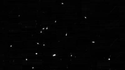
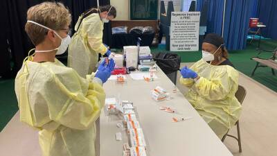
A spy satellite image showing signs of marmot burrows (small white dots in the upper right) By Stephenie LivingstonWhen the Soviet Union launched Sputnik into orbit in 1957, the United States responded with its own spy satellites.
The espionage program, known as Corona, sought to locate Soviet missile sites, but its Google Earth–like photography captured something unintended: snapshots of animals and their habitats frozen in time.
Now, by comparing these images with modern data, scientists have found a way to track the decline of biodiversity in regions that lack historic records.The researchers tested the approach on bobak marmot (Marmota bobak) populations in the grassland region of northern Kazakhstan.
Read more on sciencemag.org
The website covid-19.rehab is an aggregator of news from open sources. The source is indicated at the beginning and at the end of the announcement. You can send a complaint on the news if you find it unreliable.


COVID-19

United States
|
Cases: 46 252 513
Deaths: 750 423
Recovered: 0
|

India
|
Cases: 34 321 025
Deaths: 459 652
Recovered: 0
|

Brazil
|
Cases: 21 835 785
Deaths: 608 235
Recovered: 0
|

United Kingdom
|
Cases: 9 215 683
Deaths: 141 607
Recovered: 0
|

Russia
|
Cases: 8 494 589
Deaths: 237 619
Recovered: 0
|