Hurricane Fiona heading towards Bermuda; life-threatening swells expected to reach US East Coast
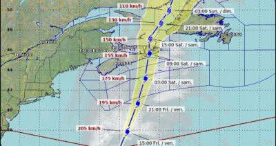
producing heavy rainfall and gusty winds on the islands in the southwest Atlantic. Fiona became the first major hurricane of the Atlantic season Wednesday and the already-deadly storm is forecast to intensify even more as it tracks toward Bermuda.Fiona has been steadily strengthening and could reach Category 4 intensity by late Wednesday as it eyes Bermuda later this week.Even with Hurricane Fiona pulling farther away from the Caribbean, its outer bands will continue to produce heavy rain over isolated portions of the Dominican Republic.
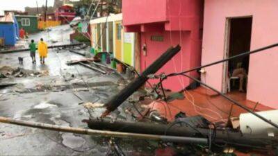
The FOX Forecast Center warns that these rains could produce additional localized life-threatening flash flooding.HOW TO WATCH FOX WEATHER ON TVFiona made two landfalls as a Category 1 hurricane, the first one Sunday afternoon along the extreme southwestern coast of Puerto Rico and the second one early Monday morning in the eastern Dominican Republic.In Puerto Rico, the city of Ponce clocked a 103-mph wind gust, while in the Dominican Republic, a gust of 98 mph was recorded in Samana at El Catey International Airport.
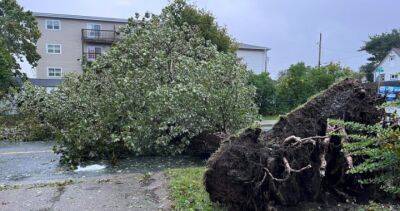
The high winds plunged all of Puerto Rico into a blackout on Sunday as catastrophic flooding unfolded across the U.S. territory.HURRICANE FIONA LEAVES TRAIL OF DESTRUCTION ACROSS PUERTO RICO, DOMINICAN REPUBLICHurricane Fiona made its first landfall in southwestern Puerto Rico on Sunday, Sept.
18, followed by a second landfall in the eastern Dominican Republic on Monday, Sept. 19. (FOX Weather) As of Wednesday morning, Fiona was a Category 3 hurricane centered more than 100 miles north-northeast of North Caicos Island and less than 700 miles south-southwest of Bermuda.
Read more on fox29.com


United States
|
Cases: 46 252 513
Deaths: 750 423
Recovered: 0
|

India
|
Cases: 34 321 025
Deaths: 459 652
Recovered: 0
|

Brazil
|
Cases: 21 835 785
Deaths: 608 235
Recovered: 0
|

United Kingdom
|
Cases: 9 215 683
Deaths: 141 607
Recovered: 0
|

Russia
|
Cases: 8 494 589
Deaths: 237 619
Recovered: 0
|