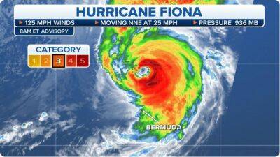
Hurricane Fiona shaping up to be ‘potentially severe event’ for Atlantic Canada
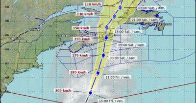
Environment Canada said Fiona is now expected to impact the eastern shore on Friday, as it transforms into a strong post-tropical storm.The weather agency said there are indications of a deep hybrid low-pressure system, which possesses both tropical and intense winter storm-type properties.
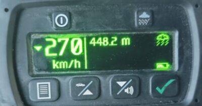
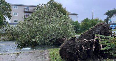
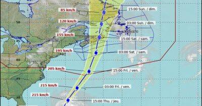
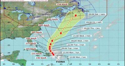
Fiona could bring very heavy rainfall and severe winds.“We’ll see some very strong, possibly damaging winds, probably a lot of heavy rainfall over some areas,” said Canadian Hurricane Centre meteorologist Ian Hubbard on Tuesday.“And we are expecting to see some coastal flooding, in terms of large waves and storm surge at some point.“ Tropical cyclone statement issued for Atlantic Canada as Fiona tracks north Hubbard said there was still a large cone of uncertainty on Tuesday, meaning there wasn’t enough detail about where Fiona would go.
It was an 800-kilometre range centred near eastern Cape Breton in Nova Scotia.On Wednesday, however, that range shrunk to about 600 to 700 kilometres, centred over Cape Breton, “with a broad coverage of hurricane-force winds including over land,” Environment Canada said.“This storm certainly has the potential to be quite severe.”A new update on Fiona from Environment Canada will be released Wednesday at 3 p.m.
AT. The agency expects to have more detail on rainfall, waves and storm surge then. Hurricane Fiona rips through Puerto Rico, unleashes landslides, knocks out power The Canadian Hurricane Centre has been monitoring hurricane Fiona as of Sunday.
Read more on globalnews.ca


United States
|
Cases: 46 252 513
Deaths: 750 423
Recovered: 0
|

India
|
Cases: 34 321 025
Deaths: 459 652
Recovered: 0
|

Brazil
|
Cases: 21 835 785
Deaths: 608 235
Recovered: 0
|

United Kingdom
|
Cases: 9 215 683
Deaths: 141 607
Recovered: 0
|

Russia
|
Cases: 8 494 589
Deaths: 237 619
Recovered: 0
|